The Apostle
Islands are a 22-island chain formed by ice, wind and waves. Sandstone cliffs, sea caves, windows and
arches, sea stacks, beaches – all surrounded
by the cold, blue water of Lake Superior.
Fishing, quarrying and lumbering were major industries here in days gone
by. For centuries the Ojibwe have fished
this area of Lake Superior. The great Chicago fire of 1871 spurred demand for
sandstone building materials quarried first on Basswood Island and then on
Hermit and Stockton. Logging decimated
the forests of white pine and hemlock; while logging here ended half a century
ago the forests are still in varying stages of recovery. Now these islands are viewed less as a source
of raw materials and more as a resource for recreation. But over and over again, you will hear “the
big lake is the boss.” Careful planning
and attention to the weather are paramount to exploring these islands.
The Apostle
Island National Lakeshore, established in 1970, comprises 21 of the 22 Apostle
Islands. (Madeline Island, the largest
of them, is open to commercial development and private ownership.) It is believed that the name Apostles came
into being in the late 1600’s due to the erroneous belief that there were only
twelve islands – the French missionaries then named the islands after the
Twelve Apostles. The islands have been
renamed several times over the years since then and none of them has retained
the name of an apostle.
 |
| Approaching Madeline Island |
On July 27th
we left Ontonagon and spent seven hours cruising to Madeline Island Yacht
Club. It was a gorgeous day for cruising
but way too long. We have had Lake
Superior pretty much to ourselves and we would welcome more camaraderie at this
point. We hear that the Apostle Islands
area has more boats per square mile than any other area on Lake Superior. We shall see.
 |
| Mooningwanekaaning - Home of the Golden Breasted Woodpecker - is the island's Ojibwe name. |
We had heard a
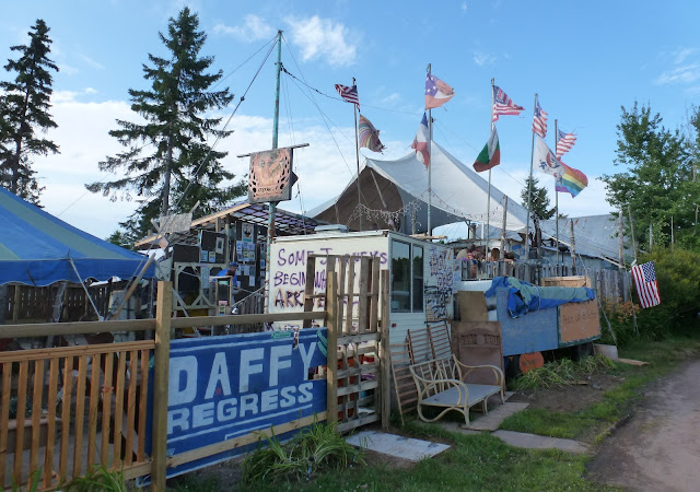
lot of talk about Tom’s Burn’d Down Café in La Pointe, the only town on
Madeline Island. So of course we had to
go there. After partaking in the
Thursday evening community pizza party at ArtBar, we went across the street to
Tom’s, an open air bar reminiscent of the Florida Keys.
 |
| Tom's Burn'd Down Café |
Leona was a
woman of the 1950’s who wanted to get away from it all. What better place to chose than Madeline
Island. In the winter, Lake Superior
between mainland Wisconsin and Madeline Island freezes over and an ice roadway
links the two – it is even maintained by the state of Wisconsin! Leona opened her beer bar and dance hall here
catering to summer tourists, winter
hunters, snow mobilers, and dog sledders.
In the late 1980’s, Leona called it quits. Enter Tom and his partners who wanted to
preserve Leona’s and its legends. They loaded the buildings onto sleds and
moved them closer to the ferry dock and spent seven cold months
renovating. Within days of opening, the
place burned to the ground! But the beer
delivery truck showed up as scheduled and Tom turned the trunk of his 1978
Impala into a new home for two kegs of beer.
He was open for business.
Improvements
over the years have included chairs and tables scavenged from the local dump
and a tarp for the roof. The floor and
half walls are a patchwork of plywood, traffic signs and old license plates.
The half walls are covered with witty observations of life. The bar patrons the day of our visit were an
eclectic bunch. An assortment of
friendly dogs were sprawled around the bar, some youngsters flopped around the
makeshift stage, and behind us at a rickety table a young gal with a nose ring
munching a pizza was getting a tattoo!?!?
Our membership
in the Great Lakes Cruising Club got us a free night of dockage at the Madeline
Island Yacht Club and we happily stayed a second day. Hopping on our bikes we pedaled six miles to Big
Bay State Park. At Big Bay Point we had
a nice view of Lake Superior.
 |
| At Big Bay State Park |
Prior to our
Lake Superior excursion, we joined the Great Lakes Cruisers Club and listened
to several of their podcasts on cruising this big lake. One of the questions they addressed was, “Can
you swim in Lake Superior?” The answer
was, “Yes you can, but you won’t like
it!” Well, Frank tried jumping in a few
times and he didn’t like it! The top 12
inches or so is a toasty 65⁰ but below that it is even much cooler. (I noticed that the anchor was quite chilled
on mornings when we left an anchorage.) However, the cold water temperatures do
not deter all swimmers on the lake.
 |
| The Captain takes a quick dip in Lake Superior |
The morning of
July 29th marked the start of the 11th annual Pointe to LaPointe Open Water
Swim. This 2.1 mile swim from Bayfield
on the mainland of Wisconsin to LaPointe on Madeline Island follows the route
of the winter ice road. From a modest
field of 24 people in 2006, this fundraiser has swelled to 400+ hearty souls
clad in wetsuits who brave the chilly waters of Lake Superior. The NOAA weather forecast noted that the
surface temperature of the lake ranged from 55⁰ to 68⁰. By the time we left Madeline Island Yacht
Club and cruised through the North Channel there were only a few swimmers still
in the water but plenty of standup paddle boarders, kayakers and Cost Guard
boats were on duty to protect and monitor the remaining swimmers. The best finishing times for men were posted
at 45+ minutes and for women 47+ minutes.
 |
| Cruising the Apostle Islands |
We continued
our cruise through the North and West Channels passing the islands of Basswood,
Oak, Stockton and Otter. All the islands
appear thickly forested just like the rest of the Lake Superior shoreline with
the exception of the spectacular Pictured Rocks National Lakeshore. The Apostle Islands National Lakeshore looks
to be a good cruising area but I am spoiled – I am awaiting more spectacular landscapes
to appear to make the trek worthwhile.
 |
| Successful anchoring off Rocky Island |
 |
| Our dinner companions off Rocky Island |
After a calm
clear night at anchor off Rocky Island it was time to hoist the anchor and move
on to further explore the surrounding islands. We made our way to the bow to
remove the snubber and lo and behold, the windlass failed to spring to
life. This was no time for the windlass
to be out of commission as we had laid out 150 feet of anchor chain!
The captain
went below to check on several things in the engine room and at the electrical
panel. After awhile he found, to his
great dismay, that the number 1 house battery that powers the windlass (among
other things) was dead. The great thing
about traveling with a captain who is a SUNY Maritime “Domer” is that he never
lets these mechanical/electrical boat issues stop us. He just keeps muddling through until he comes
up with a workable plan. And I know
enough to stay out of his way during that process. By 10:45 he had come up with a solution to
bypass the dead number 1 house battery and energize the windlass with the
number 2 house battery. We were on our
way.
After some
debate it was decided that we could anchor out one more day before having to get
to a marina and replace the house batteries.
So we cruised north to Devil’s Island where the scenery was touted as
spectacular. It did not disappoint!
 |
| The Devil's Island Lighthouse on the north shore of the island was a popular place for sightseeing. We hadn't seen this many boats on the water since Pictured Rocks! |
Devil’s Island
is the northernmost of the Apostle Islands.
To the earliest Indian inhabitants, the island seemed to possess
supernatural powers and the name they gave it meant ‘Island of Evil
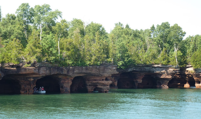
Spirit.’ The island’s north shore is
exposed to the wrath of the winter storms of Lake Superior and its sandstone
shoreline is carved with intricate sea caves and arches.
 |
| Sea caves along Devil's Island |
That night we
boldly anchored in Raspberry Bay and hoped that the windlass would not fail us
the next morning. The guide books suggested that this anchorage
would be quite crowded with weekend boaters.
Not so! By nightfall only two
sailboats had joined us there.
We had spent
three days without internet or phone access!
Our only means of checking for weather updates was NOAA weather
radio. All reports indicated that
Monday, July 31st was ‘a go’ for making the 54-mile cruise to the
twin port cities of Superior, Wisconsin/Duluth, Minnesota. With light southwest
wind, the waves were expected to be calm.
That morning the
windlass worked flawlessly and, with the anchor securely stowed, we were on our
way by 6:40AM. We rounded Sand Island
and headed west. It was a great day for
cruising.
We encountered
no boat traffic along the way until we were about 14 miles from Duluth. The heavily-loaded laker Burns Harbor was heading east on Lake Superior.
 |
| Burns Harbor |


No comments:
Post a Comment